The use of drones and 3D visualisation for urban planning, construction and operations
-
 Email
Email
-
 Facebook
-
 Linkedin
-
 Twitter
-
 Whatsapp
05 June 2023
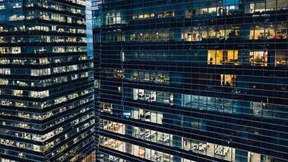
All cities rely on urban planning for their growth and development. According to the United Nations, 68% of the world’s population will live in urban areas by 2050, a 13% increase from today. This will affect transport systems, infrastructure, residential areas and much more. With the help of drones on its way, will 3D visualisation duplicate the world we live in today?
What is meant by the term urban planning?
Urban planning is the process of designing and managing the physical and social developments within urban areas such as towns and cities. The overall aim of urban planning is to create efficient, liveable, and sustainable cites. This process involves a wide range of disciplines such as geography, architecture, economics, and engineering. 3D visualisation is a powerful tool which can aid the process of urban planning to help better understand and analyse complex environments.
What is 3D Visualisation and how can it help?
3D Visualisation refers to the process of creating a digital 3D representation of real-life objects. Whether you’re buying a house or gaming on a computer, we have all seen a 3D model of some sort. 3D models of urban areas allow planners to visualise a range of different things from land use to transport system networks. This can help planners to identify potential problems and opportunities and allowing them to make informed decisions on how to allocate resources in the future.
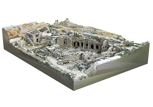
Building/structural/ Terrain 3D models
A 3D model is a digital visual representation of a building, structure, or terrain created using 3D modelling software’s that can be created during all stages of the building life cycle. 3D models can be used during construction to track progress, identify issues, and coordinate work between different teams. For example, a 3D model can be used to create detailed construction schedules, to analyse potential clashes between different systems, and to ensure that construction is proceeding according to plan. After the building has been constructed, 3D models can be used for a variety of purposes, such as creating marketing materials, assessing the building's energy performance, or planning renovations or retrofits. These models can also be used to create detailed documentation of the building's design and construction, which can be useful for maintenance and repair work in the future.
During the early design stage, they can be created using Building Information Modelling (BIM) tools. BIM us a highly specialised 3D modelling field in which the model contains the detailed 3D geometry of the structure that can be used to drive powerful visual 3D models. However, with many new assets still being proposed and built without using BIM tools, there is a huge opportunity to build 3D models for new developments, and to create 3D models for the vast number of existing assets that didn’t use BIM when they were created but would benefit from 3D models for digital twins and other approaches that support asset management and redevelopment.
What’s the difference between a BIM and 3D model?
While both BIM and 3D models involve the representation of buildings, structures, or terrains, there are key differences between them. BIM is a process that manages information about a project, including geometry, while 3D models are visual representations that emphasises the object's shape and form. A 3D model can be used as part of the BIM process to provide highly accurate and detailed data about the physical environment, which can be incorporated into the virtual model. BIM, on the other hand, can be used to manage a wide range of information about a building project, including design data, construction schedules, and cost estimates, as well as information about the building's performance over time.
Structural 3D Model
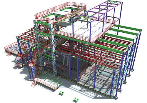
BIM model
How are 3D models utilised?
3D models can be used for a variety of purposes, including architectural design, visualisation, and simulation. They can be used to test different design options, explore the interaction of different building elements, and communicate design ideas to clients and stakeholders. As 3D models are geometrically accurate and relatively simple to make, they can be utilised within a wide range of different industries including:
- Design and Planning: Architects and engineers can use the models to visualize the building design, assess potential issues, and refine the design before construction begins.
- Marketing: Developers can create 3D models of a new building or development to showcase its design and features to potential buyers.
- Building Management and maintenance: Facility managers can use the models to identify potential issues, plan maintenance schedules, and visualize the building layout and systems.
- Construction: Contractors can use the models to better understand the design, coordinate with other trades, and identify potential issues before they arise.
- Safety Planning: Professionals can use the models to identify potential safety hazards and plan emergency response procedures.
How do you create a 3D model?
To create a digital 3D model as simply as possible, you just need, measurements, images of the building, and 3D modelling software. Traditionally, manual measurements and laser scanning were used to obtain measurements. However, manual measurements involved physically measuring the buildings or surroundings using tape measures and surveying equipment and this method was considered to be a drain in both labour costs and time. Similar to manual measurements, laser scanning is a method which involves using a laser to measure the dimensions of a building in a highly accurate manner. However, this method is relatively expensive and requires specialist equipment and trained personnel.
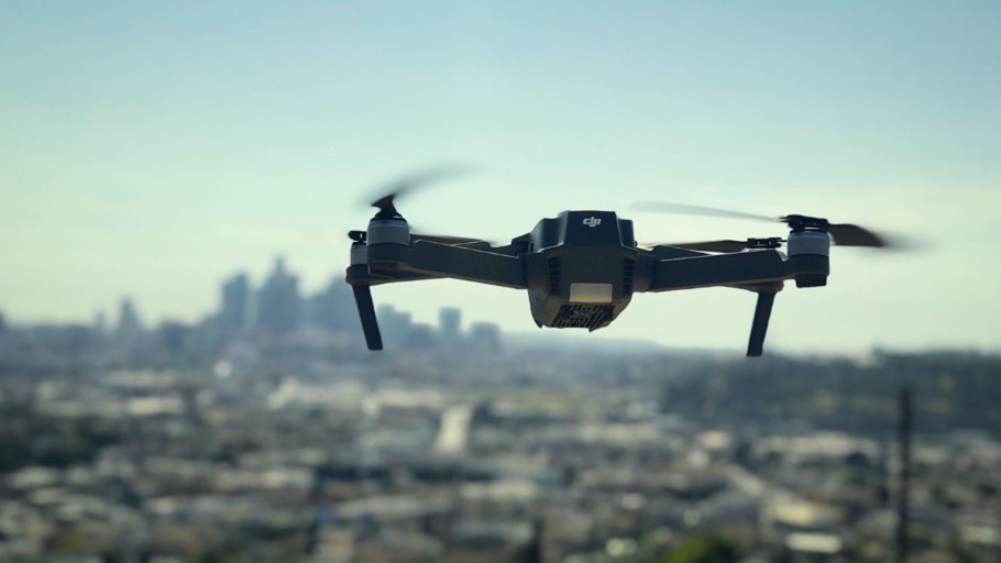
Drones can address these problems as they are able to accurately measure height through a range of different methods including LiDAR and photogrammetry.
LiDAR, which stands for light detection and ranging, is a remote sensing method that uses light, in the form of a pulsed laser, to measure ranges to the earth. LiDAR is not essential for creating 3D models; however, it is highly useful for measuring the height of buildings.
An alternative and more affordable method to using LiDAR is photogrammetry. This method involves capturing multiple images of a building at different angles and then using specialist GIS software to combine, or ‘stich’ these images and create a 3D model. These software’s can also calculate the dimensions of the building.
This is the process for creating a 3D model using a drone without LiDAR capabilities:
- Set ground control points (GCPs): Ground points are black and white squares which can be placed on the ground around the area of interest or building that is being surveyed. These points have known coordinates and act as reference points for the drone, Using GCPs reduces the margin of area during the process of surveying.
- Plan the flight path: The drone’s flight path is planned to capture images or footage of the area which is required. This includes collaborating the drone to the right angles and setting up the gimbal angle, aperture, and shutter speed.
- Capture the data: The drown is flown automatically, though this can be done manually, and it captures the images are captures in high resolution.
- Process the data: Once the data is captured, the images will then be processed using specialist software, examples can include GIS Software such as ArcPro. Software’s as such will ‘stich’ the images together, this will combine the images together with overlapping fields of view and will create a segmented panorama like image.
- Create the visualisation: The stitched image is then transferred into a 3D model by using specialist photogrammetry software such as Pix4Dmapper. This process can also involve adding textures, lighting, sand other affects to create a realistic representation of the data.
When using drones for 3D modelling it is important to consider the following factors:
- Battery size: The battery size directly reflects the flight time of a drone. Most drones used for personal use will have a battery life of 20-30 minutes, however professional drones which are used for commercial purposes will most likely have a battery life of around 55 minutes. Though this may not seem like a huge difference, a larger battery has the capacity to map a larger area in a shorter amount of time ultimately reducing labour energy and labour costs.
- Camera Quality: Most drones are now built with a 4k camera. The higher the camera quality, the better resolution that the end product will be.
- Navigation System: There are multiple types of navigation systems though the most commonly known is Global Positioning System (GPS). Another type is Real-time Kinetic (RTK) which gives about one-hundred times greater accuracy than GPS.
- Transmitter Range: A long-range radio link will allow the drone to cover areas further away as there will be a longer range of transmission.
- Stability: A gimbal is a stabilisation device which keeps the camera steady. This is important as a steady gimbal will ensure the steadiness, clarity and accuracy of the images and videos.
- Payload Capacity: This refers to how much weight the drone can carry. If the droned for commercial purposes, such as UAV mapping, then it is important that it has a high payload capacity to ensure all add-on sensors are able to be used.
- Compatibility with 3D modelling software: The drone's camera or sensor should be compatible with the 3D modelling software being used to create the 3D model.
What equipment is required?
Computer
A capable computer with decent processing power and memory is essential. The specific requirements may vary depending on the complexity of the 3D models you plan to create. It’s important to work on a computer with a dedicated graphics card for improved performance.
Software and animation
While not specifically designed for engineering purposes, 3D modelling and animation software can still be used to create 3D models of drones, especially for visual representation and rendering. A suitable package is ArcGIS Reality1, a suite of photogrammetry software which can be used every step of the way to create a 3D model from drone footage. Alternative popular choices include:
- Autodesk 3ds Max
- Autodesk Maya
- Blender
Drones
As technology advances, most drones’ professional drones on the market today will have ability to create a 3D model. To give you a better idea of the types of drones, there are four levels as well as they’re estimated price ranges.
| Practice drones | £30-£150 | $40-$190 | €35-€170 |
| Intermediate drones | £150-£300 | $190-$370 | €170-340 |
| Entry level drones | £300-£500 | $190-$620 | €340-€565 |
| Mid-range drones | £500-2,500 | $620-$3100 | €565-€2800 |
| High-end-drones | £3,000+ | $3700+ | €3400+ |
As expected, the higher the cost and quality of the drone a wider variety of uses follows. For example, a good example of a high-end drone is this is the DJI Matrice 300 RTK1. This drone is an advanced commercial drone designed for professional applications. It offers a range of capabilities and features that make it suitable for various industries, including surveying, mapping, inspection, public safety, and more.
It is important to note that this is a commercial drone and though it has extraordinary capabilities, a simple 3D model can be created using much cheaper alternatives. As long as the drone is equipped with a camera and a sensor which is able to captures images and data, a 3D model can be created.
Outsourcing services
Outsourcing drone work tends to be a preferred choice for many businesses due to several reasons. For example:
Expertise and specialisation: Outsourcing services allow you to tap into the expertise of specialised and skilled professionals. Drone service providers will have the required knowledge, experience and training in operating drones which reduces the need for you to invest in training and equipment of your own.
Cost efficiency: Outsourcing services can be cost effective compared to establishing an in-house program as it requires less investments within drones, training, certifications, and equipment. By outsourcing, you can avoid upfront costs and pay for specific purpose on a project-by-project basis. Here are example costs of outsourcing drone services.
| Per hour | £80-£190 | $100-$240 | €90-€220 |
| Per day | £650-£1200 | $800-$1,500 | €750-€1350 |
Risk Mitigation and Compliance: Drone operations come with certain risks, including safety concerns, regulatory compliance, and liability issues. Professional drone service providers are well-versed in managing these risks and ensuring compliance with local regulations. By outsourcing, you transfer these responsibilities to the service provider, reducing your exposure to potential risks and legal complexities.
What are the benefits of drones and 3D visualisation?
The utilisation of drones for creating 3D models offers tremendous advantages across various domains of the built environment, enabling accurate visualisation throughout all project stages. Gone are the days of relying solely on flat, two-dimensional representations. With the power of 3D models, we can step into a realm of immersive experiences that provide stakeholders with the ability to visualise buildings, structures, or terrains in a manner that surpasses the limitations of 2D representations. They possess the capacity to capture more comprehensive data, which can be understood more easily than with traditional planning products. The ability to comprehend and visualise data facilitates collaboration among all stakeholders, thereby enhancing communication efficiency.
In addition, 3D models can significantly streamline project planning and decision-making processes by optimising the design phase. By incorporating additional information within the 3D models, stakeholders can assess potential risks and minimize the likelihood of costly errors or construction modifications. These advantages can lead to cost and time savings in the long run.
What does the future of drones and urban planning look like?
The future of drones and 3D models used within urban planning is exciting as it holds a great potential for improving the design and development of urban areas. As drone technology improves, it is likely that drones will become more autonomous. This could allow them to navigate complex environments, such as construction sites, with minimal human intervention. This could reduce the requirement for manual labour and additional costs. Autonomous drones could be programmed to perform specific tasks, such as monitoring progress on a construction site or inspecting buildings for maintenance issues.
In addition, drones may be equipped with more advanced sensors in the future, allowing for more accurate and comprehensive data collection. For example, thermal sensors could be used to detect leaks or areas of energy loss in buildings, while LiDAR sensors can be used to create highly detailed 3D models of structures. The improvement in technology will likely result in longer flight times, faster speeds and increased payload capacity which could widen their uses and make them more efficient for tasks such as transporting materials, conducting inspections and monitoring large areas. Drones could also follow similar trends within the data and tech environment and adopt artificial intelligence and machine learning. This could allow drones to analyse data in real-time and make decisions without human input. For example, drones could be used for detecting and reporting hazards in construction sites.
Based on current trends, it seems that drones will play an integral role within the future of urban planning, and the construction and operation of buildings and infrastructure.
1https://www.esri.com/arcgis-blog/products/arcgis/imagery/introducing-arcgis-reality/
2https://www.dji.com/ch/matrice-300
Aaliyah Pollock
Data and Tech Analyst